October 1, 2021
Cryologger GVTs Deployed on Devon Island
Posted by Adam Garbo
Introduction
In August 2021, I joined the Canadian Coast Guard research icebreaker CCGS Amundsen as a Master’s student working with Dr. Luke Copland in the Laboratory for Cryospheric Research at the University of Ottawa. In addition to my MSc fieldwork, the expedition provided an opportunity to deploy a new instrument I had designed and built, the Cryologger Glacier Velocity Tracker (GVT). The GVT is an open-source, low-power GNSS system developed for long-term monitoring of glacier flow in remote Arctic environments and represents one of the first open-source glacier-velocity measurement systems deployed in the Canadian Arctic.
During Leg 3 of the expedition, I installed a set of Cryologger GVTs on two outlet glaciers of the Devon Ice Cap, Belcher Glacier and Southeast-2 Glacier (SE2). These installations were carried out in collaboration with Dr. Wes Van Wychen at the University of Waterloo, whose research uses field observations and satellite remote sensing to study glacier motion and mass-balance variability across the Canadian Arctic Archipelago.
The Devon Ice Cap
The Devon Ice Cap is one of Canada’s largest ice masses, feeding numerous outlet glaciers that drain into surrounding fjords. Two of these glaciers, Belcher Glacier on the north coast and SE2 Glacier on the eastern side of the ice cap, were selected as ideal sites for continuous GNSS-based velocity monitoring. Both systems are dynamic, with complex interactions among ice thickness, topography, and basal conditions.

Glacier flow patterns near Southeast-2 Glacier on Devon Island.
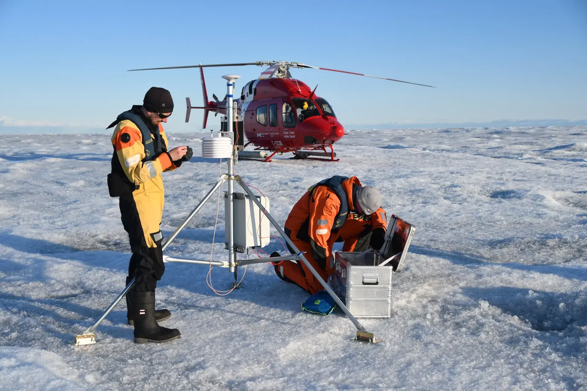
Deployment Overview
Helicopter support from the CCGS Amundsen allowed direct access to both glacier sites. After landing, each installation followed a straightforward workflow: position the free-standing Cryologger GVT tripod, level it for optimal GNSS sky view, and install a nearby ablation stake to track surface height changes during return visits.

Deployment locations of the 2021 Cryologger GVTs on Belcher Glacier and Southeast-2 Glacier.
The two installations involved different surface conditions. On Belcher Glacier, the site lay on a medial moraine, where coarse debris and uneven footing made it more difficult to seat the free-standing tripod and drive the ablation stake to a consistent depth. At SE2 Glacier, the surface was firmer and more uniform, which allowed both the tripod and stake to be installed with minimal adjustment. Together, the two sites provided complementary monitoring points on debris-covered and clean glacier ice.

Installing a Cryologger GVT on a medial moraine of Belcher Glacier.

Drilling a hole to place an ablation stake for surface-melt measurements at the Southeast-2 Glacier GVT site.
Why Glacier Velocity Tracking Matters
Understanding how glaciers move is essential for interpreting their response to climate forcing. Continuous velocity measurements provide insight into processes that cannot be captured during occasional field visits or from satellite observations alone. These records help quantify how glacier flow varies:
- seasonally, as meltwater inputs accelerate or reduce basal motion
- internally, through deformation within cold Arctic ice
- interannually, in response to changing surface mass balance and long-term climate trends
These observations support models that assess how outlet glaciers are likely to evolve in the coming decades.
The Cryologger GVT was developed as an open-source alternative to traditional commercial glacier-monitoring systems. Its combination of low power demand, high-precision GNSS, and autonomous data logging allows it to operate reliably on Arctic glaciers where access is limited and environmental conditions are severe.

Terminus of Belcher Glacier, one of Devon Island’s fastest flowing outlet glaciers.
Reflections from the Field
The 2021 deployments contributed new high-resolution GNSS observations to the long-standing monitoring record on the Devon Ice Cap. The GVTs installed that year supported research led by Dr. Wes Van Wychen and demonstrated how small, open-source, low-power GNSS systems can operate effectively on cold, fast-flowing Arctic outlet glaciers.
From a technical standpoint, the installations were also valuable for refining the Cryologger GVT design. Observing how the systems handled wind exposure, solar variability, and surface melt on Belcher and SE2 informed improvements that shaped later field campaigns.
Working directly on the ice highlighted the scale and complexity of these outlet glaciers, which can move centimetres to metres per day depending on season and location. Establishing instruments on the surface provided observational detail that complements regional velocity datasets derived from spaceborne sensors and reinforced the importance of integrating in-situ measurements with satellite-based mapping.

Aerial view of the Southeast-2 Glacier deployment site on Devon Island.
Acknowledgements
I would like to thank the captain and crew of the CCGS Amundsen for their support and expertise throughout Leg 3. This work would not have been possible without their dedication. My gratitude also extends to Amundsen Science and to helicopter pilot Sebastian Tremblay for his skill and assistance during the deployments.
Funding was provided by the Natural Sciences and Engineering Research Council of Canada (NSERC), the Canada Foundation for Innovation (CFI), the Polar Continental Shelf Program (PCSP), and the Northern Scientific Training Program (NSTP).
📷 Photo credits: Adam Garbo, Amélie Desmarais, and Sebastian Tremblay.