July 15, 2025
Cryologgers at the Equator: Monitoring Cayambe Glacier, Ecuador
Posted by Adam Garbo

Introduction
We’re excited to share a recent deployment by the CryoTartans research group of Carnegie Mellon University as part of their collaborative research project: From Peaks To Slopes To Communities, Tropical Glacierized Volcanoes As Sentinels of Global Change: Integrated Impacts On Water, Plants and Elemental Cycling where Cryologger Glacier Velocity Trackers (GVTs) were installed on Hermoso Glacier, located on Volcán Cayambe, a striking stratovolcano standing at 5,790 metres in Ecuador’s Eastern Cordillera. This fieldwork marks the first Cryologger deployment in the tropical Andes, and the highest-altitude installation to date.
The effort was led by Sam Esquivel, a first year PhD student in the CryoTartan research group at Carnegie Mellon, under the supervision of advisors David Rounce and Katherine Flanigan. The team built and deployed the Cryologger units as part of a broader interdisciplinary project on glacier–climate–ecosystem dynamics in the inner tropics. Cryologger’s open-source platform was selected for its flexibility, autonomy, and suitability for extreme environments.
🌋 Why the Tropical Andes?
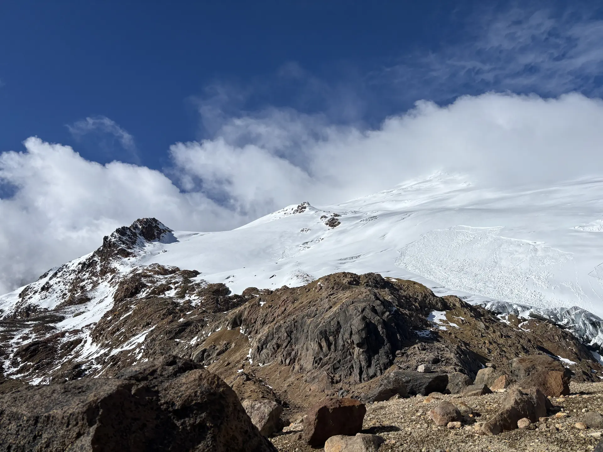
Panoramic view of Hermoso Glacier towards summit of Cayambe.
Glacierized volcanoes in the tropical Andes are some of the fastest-disappearing ice masses on Earth. Despite their rapid retreat, these glaciers remain under-monitored compared to their polar and mid-latitude counterparts. Most glaciological models and datasets have been developed for colder, more seasonal climates, yet the inner tropics present entirely different challenges.
Here, subtle seasonal variations, high-elevation páramo ecosystems, and volcanic geology create unique glacier–climate–ecosystem interactions. As tropical glaciers vanish, it's not just ice that’s lost: downstream impacts ripple through entire watersheds, altering water availability, nutrient cycling, and the distribution of plant life.
The CryoTartan’s project aims to fill this knowledge gap. By tracking glacier change on Cayambe and other peaks, the project is exploring how climate-driven glacier retreat influences water quantity and quality, plant succession, and biogeochemical fluxes, all while working closely with local communities to support long-term resilience and knowledge co-production.
🧭 Deployments on the Glacier
The Carnegie Mellon team reported that both the assembly and field deployment processes went smoothly. The updated Cryologger firmware, allowing users to modify device settings via JSON configuration files, proved especially valuable in the field, simplifying setup at high altitude. Also useful was the utility of the device’s built-in screen, allowing further confirmation of user-specified settings and certainty while arming and closing the enclosure before leaving them on site for extended periods of data collection. Equally important, the team relied on Cryologger’s open-source documentation and build guides to ensure a successful, low-friction deployment, even under challenging conditions.
Three Cryologger units were built for this project:
-
AWS Cay 1 - 4,969 m (N 00°01′04.37″ / W 078°00′14.51″)
This GVT was installed adjacent to the project’s Automatic Weather Station, collecting various on-glacier meteorological data. -
Cay 2 - 5,166 m (N 00°01'19.14" / W 078°00'08.02")
This GVT was installed with the help of local professional mountain guides. The team’s return to Ecuador in January will include an attempt to install additional GVTs closer to the summit of Cayambe. -
Antisana - To be deployed later on Volcán Antisana by collaborators.
Both Cay1 and Cay2 were successfully deployed in May 2025, logging GNSS and environmental data immediately after installation. The team included PhD students Sam Esquivel, and Claire Wilson and professor Dr. David Rounce, supported by local mountain guides for the ascent to Cay2.
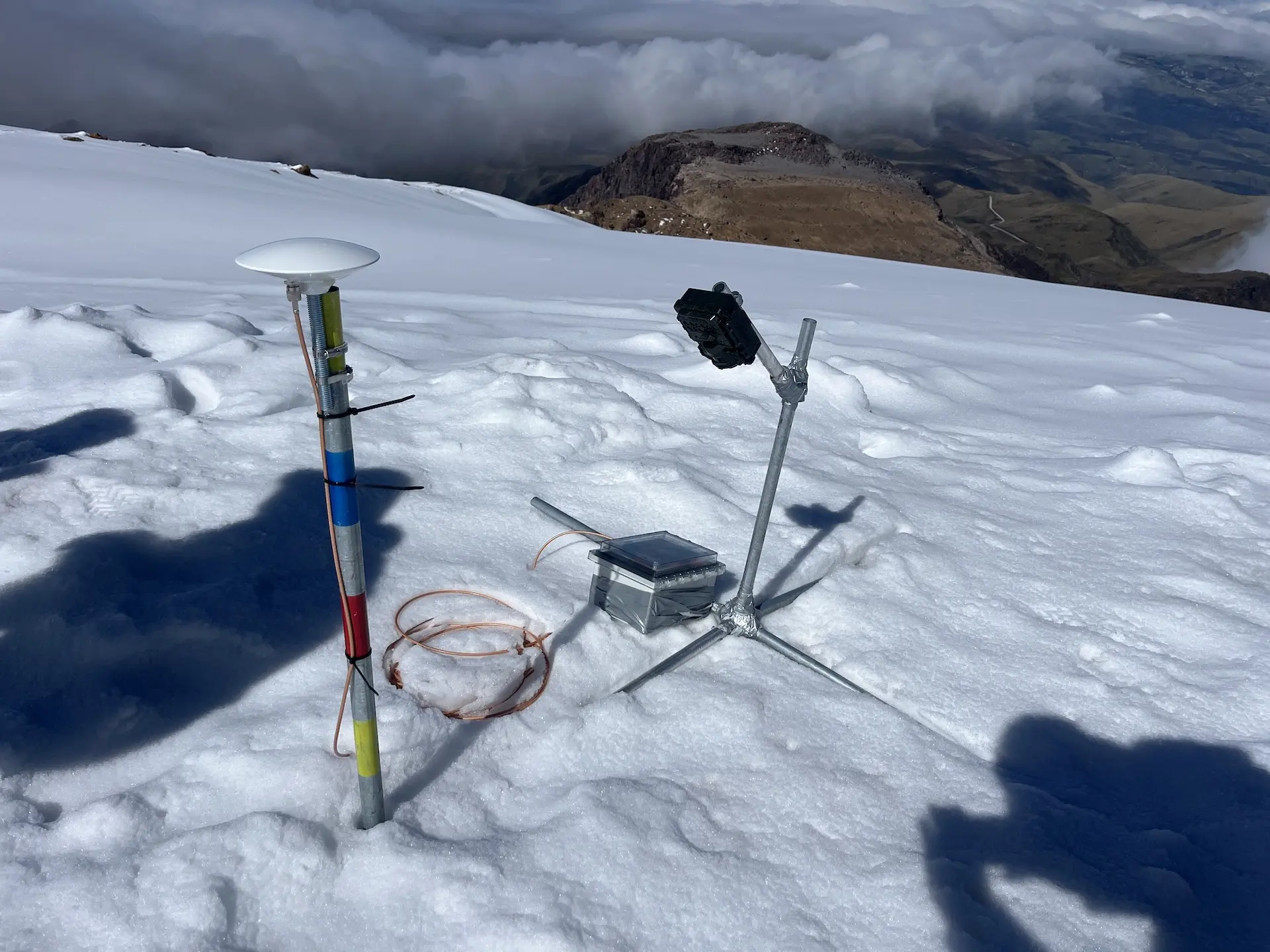
Cryologger unit Cay2 on Hermoso Glacier, Cayambe, May 2025.
🏔️ Field Logistics at Altitude
Each day began with a drive in an off-road truck up from a lower refugio (~3,350 m) where the team was being lodged, up to an upper refugio (~4,600 m) where the team would park and stage before hiking in mixed sand, rock and scramble terrain, followed by the glacier ascent. While AWS Cay1 was relatively accessible and visited multiple times, Cay2 required a one-day push towards the summit push, possible only with the help of professional guides who carried critical equipment like ablation stakes, enclosures, and the ice drill.
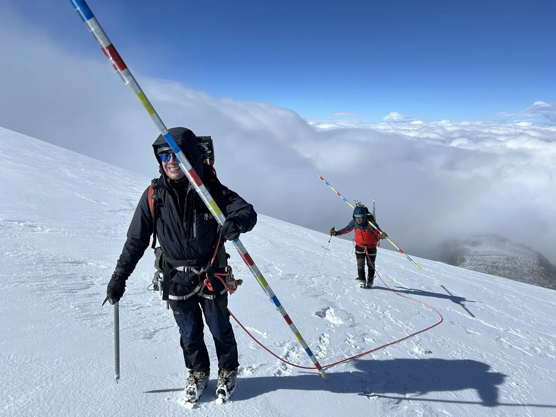
Local mountain guides supporting accent up to Cay2.
Despite the altitude, snow, and limited windows for work, the deployment was successful and well-documented. Weather conditions prevented drone surveys during the field season, but the Cryologgers captured several days of valuable data.
🧑🤝🧑 Community Collaboration
A key strength of the Cryotartan project is its close partnership with local Indigenous communities. Community members were invited to participate in site access and monitoring, especially for AWS Cay1, the lower station. The response was overwhelmingly positive. More volunteers signed up than could be accommodated, prompting the team to run glacier safety demos and training sessions in a “draft-pick” style selection event that saw ~20 people attend.
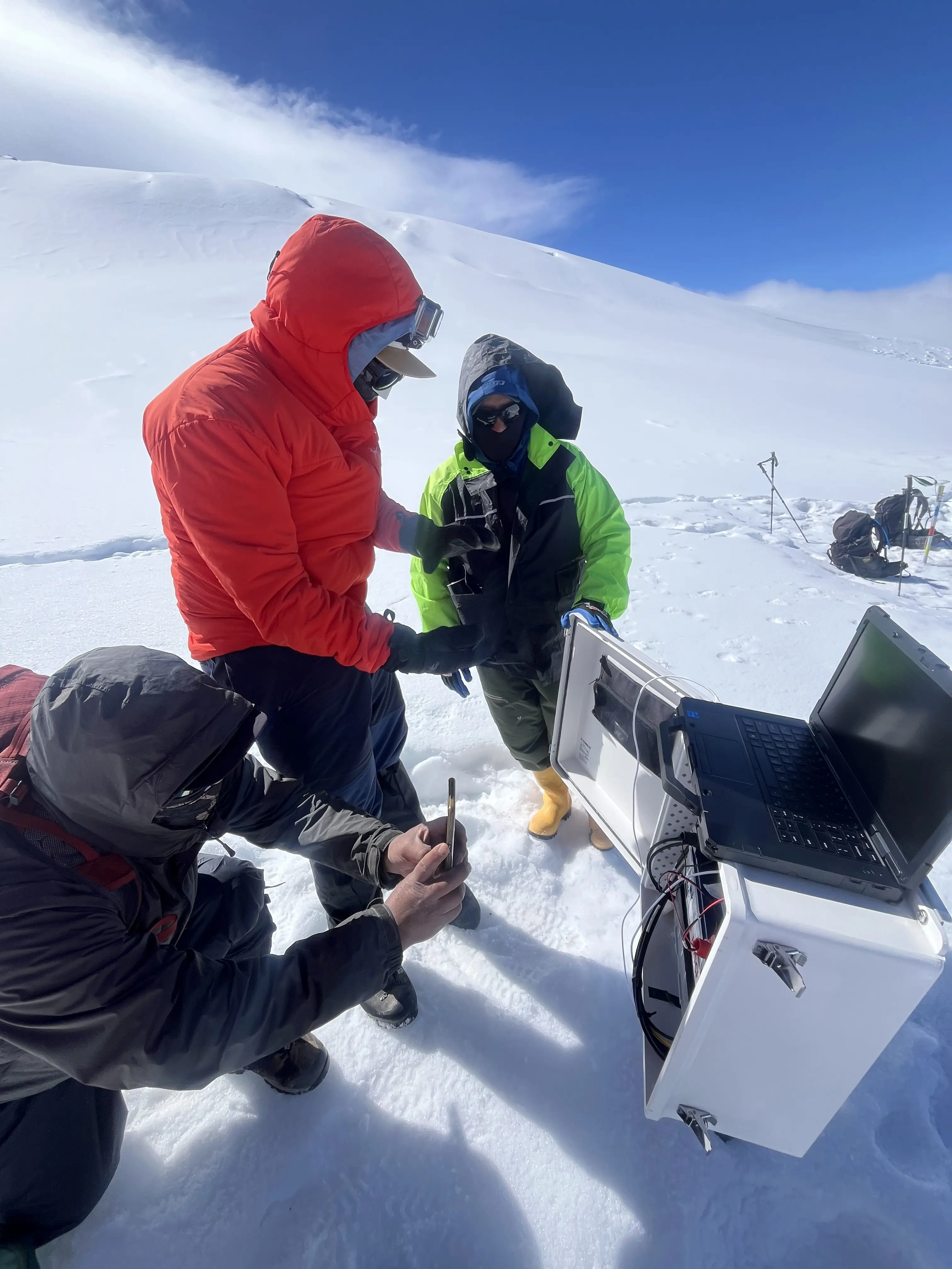
Sam showing how to collect data from the AWS, Cay1 is in the background.
The collaboration was more than symbolic: participants were paid for their time, hosted on the glacier, and trained in best practices for handling the instruments. The team is now working to establish longer-term community-led glacier and watershed monitoring programs, with an eye toward co-producing knowledge that reflects both scientific and cultural perspectives.
🔭 Looking Ahead
A follow-up trip is planned for January 2026 to service the Cryologgers and potentially deploy the third unit on Volcán Antisana. The team is also considering deploying additional GVTs on Hermoso Glacier further up and closer to the summit. These systems will continue logging autonomously in the meantime, contributing year-round insights into tropical glacier dynamics, meltwater discharge, and high-mountain ecosystem change.
The Cayambe deployment highlights the global reach of Cryologger, now spanning polar, alpine, and equatorial environments. Just as importantly, it showcases the platform’s ability to support community-engaged science in places where climate impacts are unfolding rapidly, and where data is needed most.
📷 Photo credit: Sam Esquivel, Claire Wilson, David Rounce, Jade Roland, Jeff La Frenierre